
Surveying plays a critical role in a variety of fields, from construction and real estate to agriculture and environmental management. It’s the science of accurately determining the terrestrial or three-dimensional position of points and the distances and angles between them. This article delves into the world of surveying, covering the roles of different surveyors, the advent of drone mapping, and the precision of laser scan surveying. Whether you’re a professional in the field, a student, or simply curious, these insights will guide you through the fundamentals of surveying in Australia.
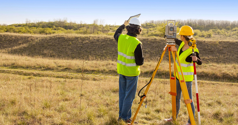
The Role of a Surveyor
A surveyor’s job is pivotal in ensuring accurate measurements for land development, construction, and mapping. They are responsible for creating precise descriptions of the surface of the earth, which is essential for establishing boundaries for ownership, location, and mapping land features. Surveyors work across various environments, from untouched land to fully developed properties, ensuring that accurate geographical information is available for planning and decision-making.
Land Surveying Explained
Land surveyors specialise in measuring properties and land to determine boundaries. This process is crucial for legal purposes, construction, and environmental management. They use a combination of fieldwork, existing records, and sophisticated technology to determine where boundary lines are situated. Land surveying ensures that property lines are accurately reflected, helps in resolving disputes, and is essential in the planning stages of projects, ensuring that developments are built on the correct parcel of land.
Property Surveying: A Closer Look
Property surveyors focus more specifically on buildings and structures within a parcel of land. They assess the condition and value of properties, which is invaluable during sales, development, and renovation projects. Property surveyors provide detailed reports that highlight potential issues, such as structural problems or zoning restrictions, that could impact the use or value of the property. Their expertise is often called upon during the purchase of a property, ensuring buyers are fully informed about what they’re investing in.
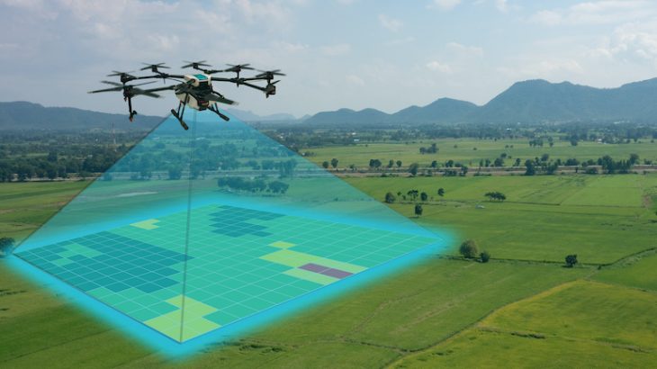
The Rise of Drone Mapping
Drone mapping represents a significant advancement in surveying technology, offering a way to gather accurate aerial data quickly and efficiently. Drones equipped with cameras and sensors can cover large areas in a fraction of the time it would take using traditional methods, providing detailed images and 3D models of landscapes, buildings, and infrastructure. This technology is particularly useful in areas that are difficult to access or in monitoring changes to landscapes over time. Drone mapping has applications in agriculture, construction, mining, and environmental monitoring, making it a versatile tool in the surveyor’s arsenal.
Precision with Laser Scan Surveying
Laser scan surveying, or LiDAR (Light Detection and Ranging), uses laser light to measure distances and create high-resolution maps and models of objects and environments. This method can rapidly produce highly accurate 3D models of landscapes, structures, and interiors. It’s especially beneficial for documenting historical sites, analysing terrain, planning construction projects, and in forensic investigations. Laser scan surveying minimises human error and significantly reduces the time needed for data collection, offering a precise and efficient alternative to traditional surveying techniques.
Embracing the Future of Surveying
As we look to the future, the field of surveying continues to evolve with the integration of advanced technologies like drone mapping and laser scan surveying. These innovations not only enhance the accuracy and efficiency of surveying practices but also open new possibilities for applications in various sectors. From urban planning and construction to environmental conservation and heritage preservation, the insights provided by modern surveying techniques are invaluable.
Professionals entering the surveying field or those seeking to incorporate these technologies into their projects will find a dynamic and increasingly essential discipline. By understanding the roles and tools of surveying, stakeholders can make informed decisions, optimise project outcomes, and contribute to sustainable development and conservation efforts.
Surveying, in its essence, connects us more deeply to the land and our built environment, providing a foundation for progress and stewardship. As technology advances, so too will our capacity to explore, understand, and interact with the world around us, ensuring that surveying remains at the forefront of shaping our future.
Hope you’ve found this post helpful and enjoyable. Feel free to share your thoughts in the comments below.